
Having trouble navigating the University of Michigan? We understand - it’s a pretty large campus! Our website features some tools that will help you find your way.
Interactive Campus Map
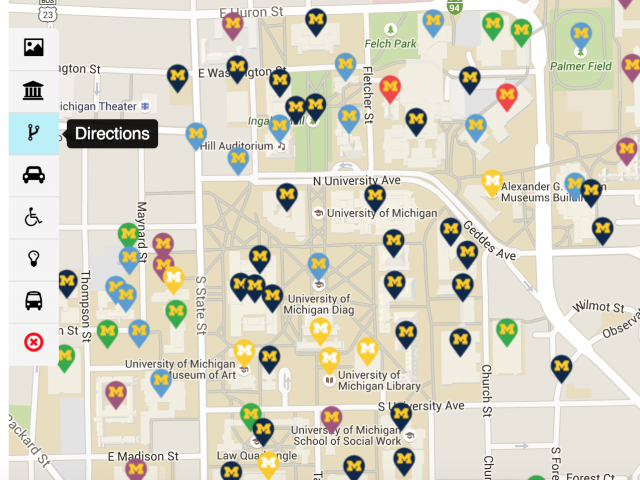
The campus map allows you to interact with it in several ways: search for specific buildings, identify directions from place to place, explore bus routes, and see parking options. The map is also available on the Michigan mobile app, which provides a map and real-time bus information on the go. When using the map, you can toggle between the four different campuses - Central, North, Medical, and Athletic. Click on the different color Block M bubbles to bring up building information. These bubbles follow the color coding below:
Academic: Navy Blue
Administrative: Green
Athletic: Orange
Housing: Purple
Library/Museums: Yellow
Medical: Red
Student Life: Light Blue
Looking for a specific department within a building? Wondering what is in each building on campus? Enter a building name, department name, room name, campus zip, or acronym into the campus map building search.
Ann Arbor Walking Map
The Ann Arbor Downtown Development Authority shares a walking map of the area on their website, as well as motor vehicle, bike, and bus routes. They also provide information regarding ongoing improvement projects that may impact various types of accessibility.
Acronym Decoder
Like every university, acronyms abound at U of M. From the OSCR to the SSWB, the names of locations and organizations can be confusing for visitors and students alike. To ease the difficulty of sorting through this alphabet soup, we created a gadget called the acronym decoder that does it for you. If you can't find the acronym you're looking for, email us and we can do our best to find out what it means and add it to our database for future searches.